 https://libraries.tas.gov.au/slat/guides-to-records/building-history/
Building history
Introduction
This guide will help you search in our collections for information on a Tasmanian building you own or are researching. You may find out when it was built, how the property looked in the past and how it has changed. You can often find out who lived or worked there, and you’re sure to discover valuable background information on the history of the local area.
The guide is divided into broad subject areas to help direct your research. Many of the resources listed under a subject area may also help with other areas, so it pays to familiarise with the whole guide.
Related Family History guides
Research tips
- You can begin by searching Libraries Tasmania collections for any references to your property. Searching across all collections is the best way to start, as you may find references in our library catalogue, Tasmanian archives resources, and the Tasmanian Index for references in newspapers, journals and more.
- Speak to previous owners or neighbours and local history organisations to gather local knowledge on the house and area. Find a list of Tasmanian organisations at The Australian Family Historian website.
- Launceston properties and country properties: a guide to research contains excellent general research tips as well as local information on Tasmania’s north.
- Digitised Tasmanian newspapers from 1810 to 1954 on Trove provide details such as sales, lettings and business information via public notices, advertisements and articles. Try searching for your suburb/street/house, owner, occupier, or business name. Use keywords that combine owner/occupant’s names and property details, and see the section below on searching in Trove.
Street names and house numbers
Street names, house numbers, suburbs and other place names can change over time for several reasons. After the Local Government Act 1906 redefined the boundaries of municipalities, many councils renumbered streets. Streets may also have been renumbered, possibly several times, for other reasons such as when land was subdivided or a street was extended. If trying to solve a street numbering puzzle, you have to be a detective and work backwards and forwards through the resources; a good way to check is to compare the position in relation to neighbours over different years. These resources may help:
- Our compilation of Hobart street name changes from Tasmanian Government Gazette
- Street and place name resources provided by the Tasmanian Family History Society
- Tasmanian historian Barry Campbell presents useful tips on researching a property in his 2021 video presentation on the Libraries Tasmania YouTube channel.
- Tips in sections below: Who lived or worked in your building; see publications in the section The wider picture.
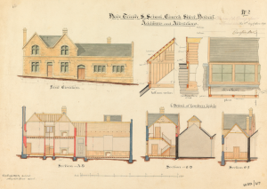
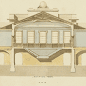
House plans and architecture
Research your building’s layout, date of construction and architectural style. You may be interested in restoring your house to its original style, or simply want information on when it was built and how it evolved over time.
House plans
The State Library and Archives of Tasmania holds a limited selection of house plans from 1900 onward. These plans are part of files of building applications and mostly comprise additions and alterations, rather than original building plans. Our collection includes the council areas of Hobart, Glenorchy, Launceston, Devonport, Clarence, Kingborough and the former council of Bruny Island. Other building plans may still be held by your local council. Not all building plans have survived, as it was not a legal requirement for councils to keep them.
To help verify the street number of your property in older plans, see tips in Who lived or worked in your building. A significant change in the rateable value of a property probably indicates subdivision, new construction, demolition or other activity.
- Hobart: Series AE417 (1919-1990)
- Glenorchy: Series AE819 (1900-1985)
- Launceston: Series LCC26 (1941-1966)
- Clarence: Series AD971 (1941-1988) (incomplete)
- Kingborough: Series AC398 (1947-1975)
- Bruny Island Series AD954 (1972-1993)
- Devonport: Series AF500 (1937-1935) Register of Building Applications for Devonport Series AF503 (1937-1935)
Plans in our collections can be viewed in the History Room (91 Murray Street, Hobart). Other building plans may still be held by your local council. If you’re not able to come to the History Room to view the plans, you may request a copy (fees and conditions apply).
Searching for plans in the councils of Hobart, Glenorchy, Launceston
- Click on the Series link above, for example Series AE819 for Glenorchy, then type the ‘street’ name (do not type in the street type). For example: ‘AE417 Bathurst’ (for Bathurst Street, Hobart).
Searching for plans in the councils of Kingborough or Clarence, and for Bruny Island
- Contact the council to obtain a building plan number.
- Click on the Series link above, for example Series AC398 for Kingborough.
- Search the items in the series to find the item that matches your building plan number. For example, plan number 2846 will be within item ‘AC398/1/14 Building approvals, plans Nos. 2733-2868.’
Other building plans may still be held by your local council. Not all building plans have survived, as it was not a legal requirement for plans to be kept by councils.
Drainage plans
Metropolitan Drainage Board Maps for the Hobart area, online resource published between 1905 and 1909 are useful for central Hobart properties from North Hobart to Battery Point, and westward to South Hobart, as well as New Town and Queenborough. These show outlines of buildings, with floor level (in feet), name major buildings and can include names of major buildings and street numbers (as they were in c.1910).
Glenorchy Municipal Drainage Plans Registers AE496 cover the Glenorchy municipality 1942-1970, although the plans themselves no longer exist. The registers detail the owner, property and date of contract completion, and are useful for dating buildings.
Architectural resources
Explore our library resources on Tasmanian buildings and architecture, for example, 1914-1941 Album of house photographs with plans and sketches – Designs of Hutchison and Walker. Architects (NS5175) (Hobart area).
Useful books in the State Library and Archives of Tasmania Reading Room include:
- Eric Ratcliff, A far microcosm : building and architecture in Van Diemen’s Land and Tasmania 1803-1914 / Eric Ratcliff. [Hobart, Tas.] : Fullers Bookshop, 2015. Comprehensive 4 volume set.
- Laurie Burchell, Recognising house styles, 1880s-1990s: Coburg [Vic.] : Coburg City Council ; Pascoe Vale South [Vic.] : Coburg Historical Society, c1991
- Miranda Morris-Nunn, Rich and chaste: building ornamentation in Victorian Launceston: [Launceston], Tas. : Queen Victoria Museum], 1989
- Miranda Morris, 100 Hobart houses 1901-2000, Hobart, Tas. : Hobart City Council, 2001
- Royal Australian Institute of Architects, Tasmanian Chapter, An architectural guide to the city of Hobart, [Hobart] : Royal Australian Institute of Architects, Tasmanian Chapter, 1984
- Malcolm Ward, Built by Seabrook : Hobart buildings constructed by the Seabrook family from the 1830s, Hobart, Tas. : M. Ward, c2006
- Michael Sharland, Stones of a century; with illustrations by the author Survey of colonial rural architecture, bridges and associated structures of Tasmania, Hobart, O.B.M., 1969
Images of your building
We are more likely to have an image of your building if it featured in prominent events or was linked to something of significant historical value, but it could very easily be included in streetscape images, aerial photographs, panoramas, albums and postcards of particular towns. Also see historic films on our YouTube channel such as Hobart: Island Capital (1962), Georgian Bothwell (1964), City of Launceston (1957) and Remembering the 1967 Bushfires (10 films). Also see recently digitised items.
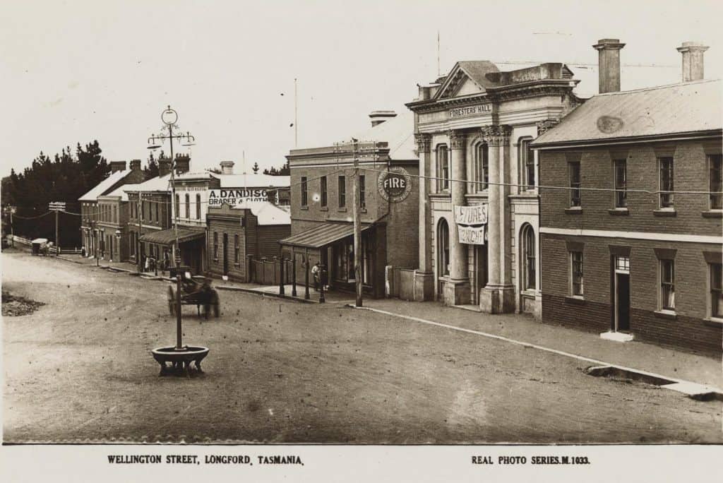
Explore our images of Tasmanian buildings online which include photographs, paintings, drawings and more. There are over 8,900 sets of images online and we add to them regularly. Some examples of what you’ll find:
- 1885 Panorama of Launceston from the fire bell tower. Series of nine photographs taken from the firebell tower on Brisbane Street, Launceston
- Southern Master Metropolitan Planning Authority maps c.1950-1983 provide building and street details for Hobart city and suburbs based on aerial photography. The earliest set goes a little further out, e.g. covers Sorell.
- Two albums of photographs [192-]-[194-] taken by Frank Heyward, a Launceston architect, of Tasmanian building and stone features. Many buildings are named; many entries include information about residents and local history. Also see indexes to the two albums
- Photographs of Hobart and Suburbs, Port Arthur and Ships (NS1231)
- Aerial photographs in Teaching Aids Centre – Photographic Prints – Sequence [1 – 12387] [AB713]
- Aerial survey of the City of Launceston, 1922. To find more than 900 aerial photographs in our collection, search Tasmanian Archives using the keywords ‘aerial’ and a location, and select the search facets ‘photograph’ and ‘online’.
To search for images that have not been digitised:
Images may be found in either the State Library of Tasmania or Tasmanian Archives collections:
- Search Tasmanian Archives for your location, limit your search to the formats you want, for example ‘photograph’ and ‘print’, and exclude the ‘online’ search facet. See our guide Searching Tasmanian Archives for assistance.
- Search the library catalogue and limit your search in the same way as for an Archives search. See our guide Search our collections (includes published resources) for assistance.
- Ask about our hardcopy card image index in the State Library and Archives of Tasmania Reading Room.
Who lived or worked in your building?
Resources such as directories and assessment and valuation rolls can help you find out who else has owned, lived in, or worked in a building, as well as when it was built or what was there before. You can cross check information between resources to help you form a timeline of who owned or lived in your property, and how street names or numbers have changed over time. It may involve a lot of detective work and will be more straightforward for properties in Hobart and Launceston.
Who were the first owners of the land your building sits on?
Our Land Grants guide may help you find the first grantees or purchasers of the land.
Early directories
Online:
- The Hobart Town directory and general guide (1852-1853) Includes geographical listing of residents.
- Middleton & Maning’s Tasmanian directory & gazetteer [1886]-1887? Geographical and alphabetical listing of residents of Hobart and Launceston.
Hobart directories available in the Hobart Reading Room:
- 1825-1829, 1831-1837, 1847, 1852, 1854, 1857, 1859 compiled from individual almanacs, annuals and directories. Later years have geographical listing of residents, while all editions have alphabetical listing.
- Hobart directory, including Sandy Bay and New Town, 1886-87. Includes geographical listing of residents.
For other alphabetical, trade and professional directories and almanacs from 1824 to 1980, see our guide to Directories and almanacs.
For maps showing landholders and sometimes individual buildings, see our guide to Maps and plans.
Tasmania post office directories 1890-1948 (Wise’s)
Tasmania post office directories 1890 – 1948 is a searchable online resource which is usually arranged in three parts: alphabetically by street for Hobart and Launceston and some larger towns such as Burnie; alphabetical lists of residents by town; alphabetical directory of both individuals and business for all of Tasmania; and trade and community directories. To verify you are looking at the right property:
- Note intersecting streets.
- House numbers can change for various reasons, and especially in earlier years there might be no numbering at all, so note the ownership of properties on either side of the property you want to trace, and use these to identify it from year to year.
Assessment and valuation rolls
Published in the Tasmanian Government Gazette up to c.1960, formerly known as Hobart Town Gazette (1825-1880) and Hobart Gazette (1881-1906).
A rates assessment of Hobart properties was done in 1847, but rates were not enacted until the establishment of Municipal Councils in 1852. The earliest Hobart and Launceston valuations occurred between 1853-1855, 1858-1860 and 1862-1863. The Rural Municipal Act of 1858 allowed for the collecting of this information in the country areas as well.
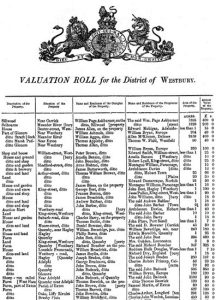
The rolls show:
- When a property first appears and gives the name of the occupant as well as the name of the owner. See ‘Post office directories’ above for more tips on identifying your property.
- Street listings in rolls for Hobart (1847, 1853-1950) and Launceston (1853-1950).
- Alphabetical occupiers’ listings for areas outside Hobart and Launceston.
- A significant change in the rateable value of a property probably indicates subdivision, new construction, demolition or other activity. It can also indicate a revaluation of a whole street. Comparison of values can confirm this.
Assessment and valuation rolls online:
- Assessment roll index : Tasmanian Government Gazette years and page numbers for Assessment Rolls Tasmanian Municipalities 1853-c.1950. Choose a location and year, note the page number, and find it in the online valuation rolls linked below.
- 1853-1890 Hobart valuation rolls in Hobart Town Gazette/Hobart Gazette. Find page numbers of rolls via index above.
- Hobart Town Gazette//Hobart Gazette/Tasmanian Government Gazette 1832-2012. Includes assessment and valuation rolls up to c.1960. Find page numbers of rolls via index above.
Please contact us if you find there any missing issues from our online valuation rolls. We also hold hard copies of indexes and valuation rolls for selected years, as well as microfilm for all years that rolls were published.
Valuation Branch (TA392)
See particularly the Government Valuations 1951-1984 (Archives record series AE298). These are organised geographically by municipality, then by division and street within each municipality.
Land Tax Branch (TA1676)
Series of valuation rolls for various Tasmanian towns for 1946-1957.
Valuation field books, Australian Taxation Office 1923-1964
These records held in the National Archives of Australia provide a comprehensive report on 533 rural Tasmanian properties. Go to Record Search and select “guest” then “Advanced Search”, Select “Series” search. Enter P2134 in series number field and any identifiers you have for the property (owner, property name or location). Digitised copies are available for some properties. Others can be requested from the National Archives Office, Hobart.
Search Tasmanian newspapers on Trove
Searching digitised Tasmanian newspapers on Trove can help to identify owners and occupiers before Assessment and Valuation Rolls began in 1847. See Trove’s Help page; and some helpful search tips on page 14 in the Launceston properties and country properties: a guide to research.
The LIST (Land Titles Office)
The LIST (Land Information System Tasmania) is an online government resource that helps you trace the history of Tasmanian land and property through the use of historic maps, plans, deeds and titles. Using the online map application LISTmap, you can view and create customised maps using multiple layers of information. Also see our Where someone lived guide on viewing copies of historic title documents.
Using occupants to find information on a property
Once you have owner and occupant information, you can use people’s names to find more details on both their life and the ongoing life of the building. See the section above on searching digitised newspapers in Trove. Use keywords that combine owners’/occupants’ names and property details. You may find the house number, name of the street and even the areas changes over time, so be flexible with your search terms.
You can also search the Tasmanian Names Index for additional information:
- Census records listed under the householder’s name for some years between 1837 and 1857 (a selection only, as most individual returns have not survived). They are more detailed from 1842, indicating address, construction type of a building – stone, brick or wood, and give details on the make-up of the household, for example name of householder, number of people generally residing there and number who were free. The return also has information on the ages, sex, religion, occupation or calling of the persons residing in the house, but usually not their names.
- Wills can be used to trace property history. If the will you are looking for is not available, you can contact the Land Data Registration Branch of the Land Titles Office, as they have copies of some wills relating to land transfers. Also see our guide to Tasmanian wills.
The wider picture: history and background of suburbs, towns, and districts
Exploring the history of your building’s locality will help you understand how your house fits into the wider picture.
See our guide to Maps & plans for early street names, structures and landmarks, for example the 1841-1846 maps compiled by James Sprent including street names, landholders and building outlines, and these two maps of Hobart Town around 1860, Map of Hobart Town showing streets, waterways, public buildings and cemeteries (R. Jarman) and Hobart Town map and street directory showing businesses and significant buildings (F. Proeschel).
Tasmanian Archives: AF393/1/58
Also see the guide to Place names and publications on geographical names in our library collection.
Search for local histories published for many parts of Tasmania. For the best results, simply type ‘history’ and the locality you’re interested in into the search box for the library catalogue, and refine results on the left hand side of the page, for example by formats such as ‘books’ or ‘online’. Heritage reviews in our collection also shed light on aspects and themes that help to understand the area and its historic physical fabric.
Accounts from people living in Tasmania in periods such as the 1830s can be useful, especially if they have good indexes. For example Henry Button’s Flotsam and jetsam, floating fragments of life in England and Tasmania: an autobiographical sketch, with an outline of the introduction of responsible government : Launceston, Tas. : A.W. Birchall, 1909 (London : Hazell, Watson and Viney).
Examples of other detailed local history publications in our collection:
- Donald Howatson, Street by street publications for central Hobart and 7 suburbs: [New Town, Tasmania] : Donald Howatson, 2011 – 2016.
- John and Don Morris, History in our streets: the origins of Launceston street names: [Launceston, Tasmania] : Launceston Historical Society, 2013.
- Historic New Norfolk series : New Norfolk, Tas. : Historical and Information Centre, Derwent Valley Council, 1996.
- Frank L. Rigney, A midlands odyssey : a journey through parts of the northern midlands of Tasmania : Launceston, Tas. : F.L. Rigney, 2008
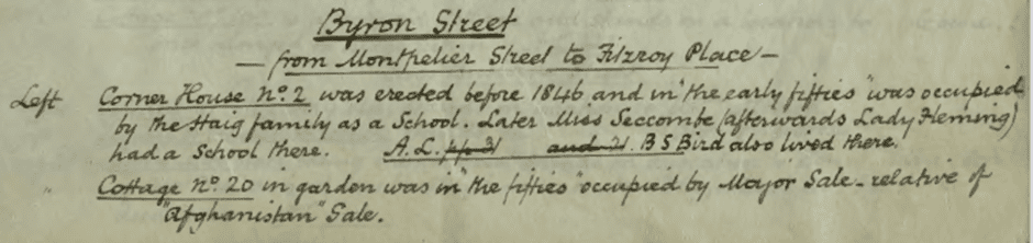
- William Graham Robertson, Hobart streets: [Hobart] : William Graham Robertson, 1919. This digitised handwritten guide provides rich detail on early 19th century Hobart streets and structures.
- Walch’s Tasmanian Almanac (also known as ‘the red book’) includes detailed annual information about Tasmania, including all regions and towns. The years 1870-1979/80 are available in the Hobart Reading Room, and 1863-1904 is available online via Ancestry Library Edition (access is onsite in our libraries only).
This selection of resources from the Launceston Local Studies Collection has a focus on northern Tasmania.
Historic buildings
If your building is very old and perhaps historically significant, these resources will help. Search by property name, if you have one, as well as by address. If you are not sure whether your property had a name in the past, search by address in LISTmap to see if a name is listed.
Helpful Libraries Tasmania resources include:
- A selection of publications in our collection on historic buildings.
- Heritage reviews, which may mention your historic building.
- Tasmanian Indexes and other useful historic newspaper resources including:
- The Tasmanian Index 1966-1994 – a digitised card index to Tasmanian newspapers, journals and some other important early publications such as John West’s History of Tasmania (1852) and the Cyclopedia of Tasmania (1900 and 1931). Useful for property and people searches.
- The Tasmanian Index 1994-2010 – an online database indexing the three Tasmanian daily newspapers, the district newspapers, major Tasmanian serial publications, and a wide range of books about Tasmania’s built heritage. Contains detailed references to places, people and events.
- Whitfeld Index (Tasmanian Section) – a selective index of personal names found in Tasmanian colonial newspapers 1816-c.1900, mostly relevant to Northern Tasmania, as well as a subsection of topical and geographic entries. Emphasis on members of early settler and eminent families and includes land grants and property sales.
Heritage Tasmania has the latest register of Tasmanian heritage properties available for viewing and downloading. Also see Heritage Tasmania publications [electronic resource] and publication The heritage of Tasmania : the illustrated register of the National Estate.
The Tasmanian Family History Society provides a Comprehensive Subject Index-CSI on the Web (tasfhs.org), a searchable database of references to named people, objects, places or events.
Buildings with past uses
- Buildings such as churches, hospitals, and hotels that required registration.
See Public places and Government buildings. As registrations were gazetted in local newspapers, searching digitised newspapers on Trove may also be helpful. - Churches and church buildings
Information may also be found among the records of the particular denomination; for example, search ‘Anglican Church of Tasmania’ in an Archives search.
- Hotels and guest houses
- Search the Tasmanian Names Index for information on hotel licensees, inquests into fires, Launceston buildings and demolished hotels.
- View this list of our publications on the history of guest houses and hotels.
- Also see our guide to Hotels & publicans’ licences.
- General businesses/industry
- Lindy Scripps, Industrial heritage of Hobart: [Hobart, Tas. : Hobart City Council], 1997
- Morris, Miranda and Tassell, C. B., Launceston’s industrial heritage: a survey, [Launceston, Tas. : s.n.], 1982-1983
- Miranda Morris-Nunn and C.B. Tassell., Tamar Valley industrial heritage: a survey: [Launceston, Tas.? : M. Morris-Nunn and C.B. Tassell?], 1984
- Wapping History Group, Down Wapping : Hobart’s vanished Wapping and Old Wharf districts: Hobart : Blubber Head Press, 1994.
- Hobart Town map and street directory showing businesses and significant buildings, F. Proeschel, 1860.
- c.1830 – 1890 Business Advertisements Index. This card index accessible through the Hobart Reading Room records business advertisements in the Tasmanian Directories and Almanacs, giving locations.
- Local council records
Some local council records include plans of buildings and facilities for some periods, for example, MCC28 Queenstown Municipal Council and MCC26 Port Cygnet Municipal Council.
Public places
Buildings that were used as public places were inspected by government officials – These series can be examined when the records are open – some are on closed access for 25 years. There are some restrictions on accessing personal information.
- AD772 – this series contains plans of public entertainment, and plans of sewerage, drainage and abattoirs. (1954-1976) Open Access.
- AD712 – (in North and North-Eastern Tasmania) – created by the Public Health Division, this series includes sports clubs, community centres, public toilets, licensed premises, restaurants and cafes. (1950-1990) Access: D25 years
- AD706 – (North and North Eastern Tasmania) created initially by the Public Health Division, this series includes motels, sports clubs, restaurants, hotels, nursing homes, hospitals public toilets, churches, public halls, community centres, public toilets, licensed premises, and cafes. (1956-1995) Access: D25years
- HSD1 – General Correspondence files of the Department of Public Health (1930-1945) Very wide variety of subjects including halls, wharves, abattoirs and hospitals. Open Access
- HSD5 – General Correspondence files of the Department of Public Health (1946-1990) Very wide variety of subjects including places of public entertainment, food hygiene, mothercraft and child health. D25 years
Government buildings
Tracing the history of government buildings entails many of the approaches already described. In addition, they have their own unique records and strategies that set them apart from researching private property. Government buildings may have been built or acquired by government.
Commonwealth buildings
Buildings utilised for Federal/Commonwealth purposes can be found in the holdings of the National Archives of Australia. Such buildings include post offices, customs house, defence buildings. Search online or visit their office at 91 Murray Street for more information.
State Government buildings
The Colonial Secretary’s Office and subsequent agencies were responsible for the building of many of the earliest Tasmanian Government buildings.
- See A Guide to the Public Records of Tasmania – Colonial Secretaries Office
- You may need to search registers and indexes (in hardcopy and microfilm) as well as online indexes such as the Wayn index, for mentions of certain buildings.
- The Public Works Department (1835 – 1977) was responsible for the construction and maintenance of public buildings and infrastructure. There are over 260 individual series of records for the Public Works Department. Some series are highlighted here; many more describe contacts, tenders, specifications and general and specific types of government building and infrastructure construction. To see all possible sources search agency TA24 and check the online finding guide Index to public works 1877-1935 for public works that were approved by the Tasmanian Parliament to commence construction during the indicated year.
Some useful records include:
- PWD266 – plans of public buildings and infrastructure between 1834 and 1995 (police stations, court houses, gaols, government offices, hospitals, schools, railways, bridges and jetties). Many plans are listed by name as items within PWD266. Many plans are available on microfilm aperture card. Selected ones have been digitised and can be viewed online.
- PWD18 – Correspondence and Associated Papers Relating to Various Works Provided for in Public Works Execution Acts, 1877-1936.
- PWD29 – General Government buildings, arranged by municipalities.
- PWD70 – Accommodation houses.
- PWD57 – Health.
- PWD54 – Department of Education.
- PWD55 – Police.
- PWD261 – General Government buildings, arranged alphabetically by department – much of the correspondence is about interiors.
Individual government departments that built and/or owned their own buildings can hold records on the construction of their building. Search through the individual department (agency search), looking for series created by the Department (such as correspondence, minutes, photographic series). For example, the Education Department (TA63) has many correspondence files relating to schools and early indexes, registers and letter books that can be used to compile school building histories. Marine Board of Hobart (TA71) minutes can be used to trace buildings used for marine and harbour purposes.
Parliamentary Standing Committees on Public Works – Various published reports of Journals and Printed Papers of Parliament are held in the Hobart reference collection.
Local Government buildings
Records of council-owned or council-acquired buildings can be found in the records of the individual councils using a Tasmanian Archives search by council name. See our guide Searching Tasmanian Archives for assistance.